

Where Adventure Meets Antiquity
Lough Navar Forest is a magnificent site within the Geopark. Extending across 2,600 hectares of bog, heath, open water, native woodland, and coniferous forest, there’s plenty to explore within this spectacular forest. The forest is located approximately 7.5 miles / 12km from Derrygonnelly and is rich in natural and historical antiquities. It is also home to one of the most breathtaking views in the island of Ireland, over the Magho Cliffs. It is hardly surprising that this forest is a mecca for walkers, fishermen and outdoor enthusiasts.
Lough Navar Forest along with Carrigan, Big Dog, Conagher and Ballintempo forests in west Fermanagh combine to form the largest continuous tract of forest in Northern Ireland covering over 8,500 hectares.
Carrick Lough Viewpoint
Carrick Lough Viewpoint is located at the entrance to Lough Navar Forest. A short walk from the carpark takes you through open forest to a viewing area from which Carrick Lough can be seen. Also visible from here are the remains of an ancient Crannog, which can be described as an artificially made small island farmstead.
Aghameelan Viewpoint
Aghameelan Viewpoint provides picturesque views over much of the County Fermanagh countryside and beyond into County Cavan. A patchwork of bog, heath, limestone grasslands and open water are clearly visible. Knockmore Cliff, which is comprised of carboniferous limestone, is a dominant feature of the landscape to the south. Evidence of Ireland’s glacial past is also clearly visible in the many drumlin hills dotted around the surrounding countryside.
Walking Trails
- Distance: 2.5 miles / 4.5km
- Time: 1/2 hours
- Ascent: 60m
- Grade: Moderate
- Terrain: Approximately 3.5km of the route is on existing forest track with 1km section surrounding the waterfall on forest ground which can be damp underfoot. Suitable for people with a moderate level of fitness. Specific outdoor walking footwear and clothing required.
- Route: Circular
- Wheelchair accessible: No
- Map: Discoverer Series OSNI Sheet 17 Lower Lough Erne; Activity Map OSNI Upper and Lower Lough Erne
- Waymarking: Black Arrow on White Background
- Dogs: Dogs must be kept under control and waste disposed of
- Starting Point: Aghameelan Viewpoint Carpark

The trail takes you deep into Blackslee Forest, along forest tracks, where coniferous plantations comprising mainly of Sitka spruce dominate. Dotted along the route are many areas where the coniferous tree cover is sparse and light freely penetrates the floor creating a delicate and aromatic woodland carpet of wood sorrel, wild garlic and bluebells in the spring. This is in contrast to the fringes of the forest tracks where heathland and bog plants dominate. Heathland habitats are usually intertwined with peatland or bog habitats and are extremely hard to differentiate as they contain many of the same plants and animals.
Keep your eyes peeled and you might be lucky enough to see some of our native wildlife along the route. One of the most intriguing mammals found in Lough Navar Forest are deer. Of the three types of wild deer found on the island of Ireland, only Red Deer is native. These captivating mammals are common place within the forest. Remember to look down as well as straight ahead to catch a glimpse of these mammals.
The most spectacular feature of this walk is Blackslee Waterfall. The sights and sounds of this small stream tumbling over the sandstone rocks is well worth experiencing – It is undoubtedly the highlight of this unique trail.
This walk is situated in a working forest environment and may be subject to temporary diversion so please ensure that all safety signage is complied with.
- Distance: 1.5 miles / 2.5km
- Grade: Moderate
- Terrain: All types, mostly forest track
- Route: Circular
- Wheelchair accessible: No
- Dogs: Dogs must be kept under control and waste disposed of
- Starting Point: Lough Achork carpark

A path has been provided which circles this pleasant lake and offers views across the lake and its surrounding rugged hills. Lough Achork is the source of the Sillees River which runs through the nearby Correl Glen to eventually join Lough Erne near Enniskillen. The sheltered location of the lake and fringing woodland with its abundance of food make the area a popular haven for birds, otters, ducks, swans, foxes, deer, hares which can often be spotted feeding, nesting, or rearing their young in the area all year round.
Awaken your senses and become a Geopark explorer as you delve into the many layers of the fascinating landscape of Lough Navar and Lough Achork. Recount the stories of St. Faber in our reading area, explore the landscape using our 3D information panels, complete our interactive scavenger hunt or sit in our forest bathing area and listen to the sounds and stories of the forest.
Lough Achork is open to anglers with fishing permits and are well populated with good stocks of brown trout.
- Distance: 7 miles / 11km
- Time: 1 hour 30 minutes
- Grade: Moderate
- Terrain: All types, mostly forest track
- Route: Circular
- Wheelchair accessible: No
- Map: Discoverer Series OSNI Sheet 17 Lower Lough Erne; Activity Map OSNI Upper and Lower Lough Erne
- Starting Point: Lough Achork carpark

The initial part of this walk is along the scenic drive past Old Man’s Head; a sandstone scarp which resembles the profile of an elderly gentleman. The walk then skirts the western shoreline of Lough Meenameen before leaving the shoreline and disappearing deep into the heart of the forest leading to a junction where the obvious path will take you through deep corridors of planted Sitka spruce and lodge pole pine. Through the trees in the distance, you may glimpse Lough Navar and on the opposite side of the track is Lough Naman, a raised bog lake. This area is designated an Area of Special Scientific Interest (ASSI) and is home to a number of interesting species of plants including bog cotton, sedges and the tiny carnivorous plant, sundew. After passing Lough Navar and Lough Naman the walk leads you along the forest track before re-joining the scenic drive to begin its gradual but steady climb to Lough Achork. As you leave the forest track you will cross the Sillees River where a brief detour branching off to the Lough Achork shoreline offers fine views of the lake and surrounding area.
Lough Meenameen and Lough Achork are open to anglers with fishing permits and are well populated with good stocks of brown trout.
- Distance: 1.5 miles / 2.5
- Grade: Difficult
- Terrain: Mostly forest track
- Route: Linear
- Wheelchair accessible: No
- Dogs: Dogs must be kept under control and waste disposed of
- Starting Point: Magho Cliffs Viewpoint carpark
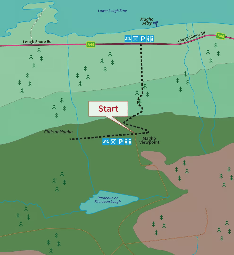
Magho Cliffs are a 5.5 miles long limestone escarpment dominating the southern shore and skyline of Lower Lough Erne on the northern edge of Lough Navar Forest.
For the initial part of the walk take the path leading to the left as it will take you across the top of Magho Cliffs offering great panoramic views of the surrounding area. At a height of 300m, the viewpoint offers a bird’s eye view across Lower Lough Erne, far into counties Fermanagh, Sligo, Tyrone, and Donegal and even as far as the Wild Atlantic Way. At the end of this path take a moment to rest on the bench provided and soak in the tranquil atmosphere. The cliffs are an Area of Special Scientific Interest as they support an exceptional range of habitats. The abundance of wildlife is very evident, keep an eye out for the array of butterflies and birds feeding in the area. To continue the walk, return back along the cliff top path and follow the black route way markers which will bring you down the cliff twisting and winding its way through the woodland with patches of open area providing great glimpses of the cliff escarpment.
You also have the option of parking in the carpark on the Lough Shore Road (toilets are available here) and doing this walk the opposite way around.